In today’s rapidly evolving business landscape, the ability to make agile yet informed decisions is more critical than ever. While organisations are capturing larger volumes of data than ever before, most of this data remains ‘dark’, meaning it is stored but not strategically deployed for business gains.
This occurs for a number of reasons. Compliance sensitivities around data protection often results in organisations being uneasy about using their data. Poor management of data can see it stored in unusable formats or dormant content servers. Organisational silos and lack of collaboration between teams can also result in dark data that is not optimally deployed for the company’s gain.
Geospatial intelligence is fast becoming a cornerstone of strategy and operations. For businesses to remain ahead, it is critical that they light up their dark geospatial data and derive location-based insights that are powerful enhancers of performance.
Why Geospatial Intelligence Matters
At GeoINT, we are of the opinion that geospatial intelligence (incorporating GeoAI) and spatial visualisation have the potential to redefine the way that leaders make and execute decisions.
Everything happens somewhere. Regardless of the nature of an organisation or the sector in which it operates, practically every business engages customers that live, buy or need to be serviced in a given location. Some businesses rely on understanding the movement of people to achieve their objectives. Others rely on complex logistical fleets and operations as a backbone of their competitive advantage.
Understanding the demographic data of a given areas sheds light on how lucrative it may be to businesses seeking geographic expansion. Understanding how people move within that area can help to uncover where it may be convenient for them to stop and shop, or on what routes advertising ROI will be optimised.
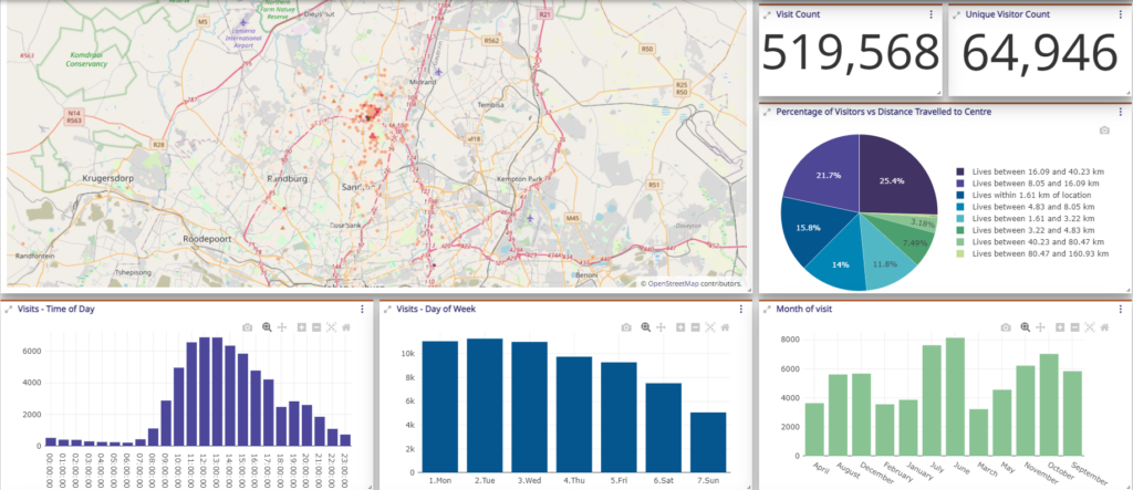
Visualising the concentration and dispersion of customers in an area can enable organisations to plan sales routing and deploy service agents accordingly for efficient operations and higher customer satisfaction.
Ultimately, geospatial intelligence provides rich and unique, data-based insights that lead to more robust and effective strategic planning and operations management.
The Genesis of MapSTACK
Based on requests from our clients, GeoINT identified the need for a locally developed, visualisation tool that combines well with our deep spatial analytics skills to make geospatial data accessible, visible and useful to organisations. This led to the birth of MapSTACK, a product developed to transform geospatial data into actionable insights that empower business leaders to better harness their location data in their strategic decision making.
MapSTACK’s interface is highly visual and intuitive, negating the need for sifting through reams of raw data or complex interpretation. The platform combines various data sources to uncover powerful intelligence that is readily accessible for integrating into existing business processes.
What Makes MapSTACK Unique?
In a world where data-driven decision-making is paramount, having the right tools to interpret and leverage geospatial information is critical. GeoINT’s MapSTACK, backed by over 20 years of experience in location intelligence, is designed to meet this need.
MapSTACK is designed to integrate with existing systems, allowing for rapid deployment and minimal disruption. Robust and scalable, it adapts effortlessly to the needs of different verticals, providing sector-relevant insights. It is highly flexible, supporting diverse applications and growing data demands.
Real-World Applications of MapSTACK – In Action
MapSTACK is not just a tool; it’s a robust solution with multiple mainstream applications that drive real business results. Here are a few examples of how it’s being used across various sectors:
- Finding the Perfect Retail Location: In the retail sector, choosing the right location for a new outlet is critical. MapSTACK enables retailers to enrich their strategies using a variety of data—such as population density, income levels, movement patterns, and proximity to competitors—to evaluate and identify locations with the greatest potential for success.
- Maximising the Impact of Your Marketing: When investing in out-of-home advertising, location is everything. MapSTACK optimises ad placements by providing insights into high-traffic areas, consumer demographics, and movement patterns of target audiences, ensuring that advertising efforts are highly visible and deliver optimal ROI.
- Optimising Service Routes with Ease: For businesses that service customers over a wide geography, MapSTACK identifies customer locations relative to service agents and plans the optimal service routing. This enhances client satisfaction and maximises operational efficiency.
The future of strategic decision-making lies in the intelligent use of location data—because everything happens somewhere.
Discover how MapSTACK’s powerful features can enhance your strategies in retail, marketing effectiveness, and beyond. Plus, get an exclusive sneak peek into the exciting new features we’ll be launching early next year!

Register for our Webinar and learn more about how you can light up your dark geospatial data.
Date: 3 October 2024
Time: 3pm 3h30pm (GMT)
Click the link below to register
Register here to see how to light up your dark data.