A Partners View
MapIT a company of the GeoINT Group has been a TomTom African partner for more than 20 years. With extensive experience and expertise in putting mapping technology to work, we are excited to bring Orbis to the African market.
TomTom Orbis Maps is already disrupting the map landscape in 235+ countries and territories around the world through increased interoperability, open source innovation and collaboration; and will soon deliver much-needed map innovation across Africa.

TomTom Orbis Maps integrates the best of open and proprietary data sources to deliver the world’s freshest, richest, most accurate maps. Through collaboration with the open-source community, leading tech and automotive partners, TomTom Orbis Maps are standardised and interoperable.
The Overture Maps Foundation, steered by Amazon, Meta, Microsoft and TomTom, was founded in 2022 to advance today’s most prevalently used maps, addressing the many challenges faced by map developers, chief of which include:
- The complex and costly task of collecting and updating high-quality data from multiple sources
- Datasets from multiple sources using varying conventions, making integration difficult
- Suboptimal fit of map data for commercial application
- Stifled innovation due to the constraints of isolated maps and a lack of interoperability
The result is TomTom Orbis Maps. TomTom is the first global mapmaker to build its map stack through open source innovation, creating a much-needed and improved universal industry standard. Its easy-to-use, and interoperable map data will solve these challenges and disrupt the status quo of current and next-generation map products.
What are the benefits of TomTom Orbis?
‘In setting a new industry standard, this open-source innovation presents vast potential for revenue generation and diverse commercial applications across various sectors.’
TomTom Orbis Maps foster innovation and customisation, allowing users to contribute to and blend their own data with TomTom’s proprietary data as well as an evaluated and curated sets of open data.
The result is access to maps of heightened granularity but also to bespoke layers of information on these maps that are unique to your organisation. This will transform maps into powerful, proprietary business tools, enhancing their utility across various applications, from urban planning to logistics and beyond.
TomTom Orbis Maps are:
- Scalable – making it easy to expand coverage and enter new markets.
- Highly granular – thanks to the combination of open and proprietary data.
- Fast growing – with data that is constantly being added to the map.
- Flexible – allowing users to add, remove, and blend data as they need.

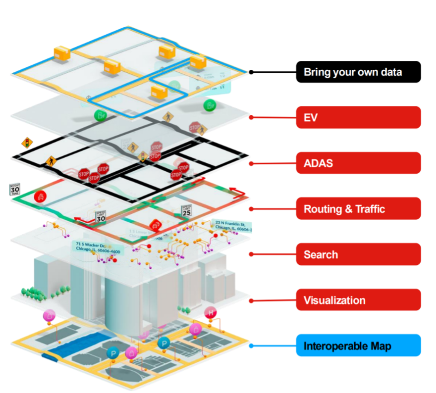
TomTom’s new Orbis Maps builds map and location tech from multiple layers. These include an interoperable base map co-created with Overture, private data, visualisation, routing, traffic and POIs.
Legend:
- Gray data layer is built with Overture;
- Black data layers use TomTom data;
- Green data layers are your own (customer) data.
Bring Your Own Data
TomTom Orbis Maps allows clients to bring their own data (BYOD) and keep it private for their own use while integrating this with TomTom data and myriad other open data sets to provide never before seen levels of granularity and business relevance.
Consider a mine with private road networks. They would now be able to route trucks to specific areas of the mine without having their mine footprint exposed in a public-facing map.
Similarly, ride-sharing organisations could display areas of high potential value for their drivers without displaying these on a map visible to their competitors. Following this strategy, Bolt selects TomTom Traffic to power ride-hailing and food delivery worldwide.
Curated OSM and super sources of data
With super sources of data, of which OSM (Open Street Maps) is a major part, integrating into TomTom Orbis Maps, the global scale and resolution of these increases dramatically.
The greater the address point granularity, the better the routing and address verification is for map users. This means better ETA’s, better routing and fewer returned goods due to incorrect addresses.
Open standards & integration
By supporting open data structures, TomTom Orbis Maps is that much easier to integrate into your business. Quicker and easier integration means that innovation can be pursued and the time-to-market of products drastically reduced.
Lower required development time and numerous layers of interconnected data enables a user to swiftly answer questions that have previously needed multiple systems to answer, or simply could not be answered.
Stay tuned for additional TomTom Orbis Maps content!
We will be publishing additional content in the coming months leading up to its launch in Africa, with a focus on practical business use cases.
Interested to get ahead of the curve and learn how we can unleash TomTom Orbis Maps for you?
Reach out to us here.


